
Buckhall ZIP Code Coverage Evidence
Official local evidence documents one ZIP code directly connected with Buckhall. The county's ZIP publication identifies 20111 as “Manassas, Buckhall,” but it reports selected county address ranges rather than a complete legal boundary for the Buckhall CDP. That distinction controls the table: the first row states the documented result, and the second preserves the official research gap instead of assigning the whole CDP a ZIP code without an address-level check.
| ZIP | Documented Buckhall Area | Post Office Label | Record-Use Note |
|---|---|---|---|
| 20111 | Selected Centreville Road and Shoppers Square ranges identified by the county | Manassas | County table labels it “Manassas, Buckhall”; it is partial-range evidence, not a CDP boundary |
| Other CDP overlap | No full official Buckhall CDP-to-ZIP crosswalk was located | Verify at the address level | Do not infer another ZIP from a third-party boundary image or a nearby address |
The county table is a strong starting point. It does not establish that every 20111 address lies in Buckhall or that every Buckhall address uses 20111. Parcel identity, the county Street Directory, and an official delivery check resolve a particular address more reliably.
Verify Buckhall ZIP Address Ranges
The county's ZIP code publication gives precise local clues for 20111. It lists Centreville Road ranges around 7200 through 8393, plus the specified 8590, 8591, 8595, and 8605 addresses. It also lists Shoppers Square ranges 8260 through 8283. A later county recycling report uses the broader shorthand “Manassas/Buckhall, 7200–8605 Centreville Rd.” Use the narrower publication when checking a particular range.
Those documents do not conflict so much as they operate at different levels of detail. The broad shorthand helps orient a reader. The narrower table is safer for address-range work. If a number falls near an edge, retain the full source and query date, then check the county parcel and the official delivery tool rather than extending a range by guesswork.
Note: A documented 20111 range is a local postal clue, not proof of a municipal boundary, parcel boundary, or complete Buckhall CDP extent.
Search Buckhall ZIP Codes by Parcel
No captured official source established a ZIP-only public parcel filter or a ZIP-wide public voter roster for Buckhall. The reliable ZIP-oriented route begins with a documented range or full address, then narrows through the county's address and parcel tools. That approach returns a checkable parcel rather than an unsupported list of people connected to a postal area.
- Start with the county ZIP range table and the full street address. Preserve the street suffix and the Manassas mailing label if it appears.
- Check the address in Prince William PublicAccessNow using its Address Search. Capture the property address, owner-of-record display, legal description, GPIN or account, and source date.
- Enter the address in County Mapper. Street Name is required there, while a number is optional. Compare the parcel result with the county ZIP evidence.
- Use the official delivery lookup to confirm the delivery ZIP for that exact street address, city, and state. The researched USPS form did not provide a captured live Buckhall result, so record the result date.
- Once the ZIP and parcel are clear, use the Buckhall street directory for the full address-to-owner and deed workflow.
The GPIN is the durable county key after an address is found. It can bridge PublicAccessNow, County Mapper, the Street Directory, and a deed trail even when a postal label or street spelling changes over time.
Confirm a Buckhall Delivery ZIP
The official USPS ZIP Code Lookup is the final delivery-address check. It is an address-level form, not a source for defining the Buckhall CDP or Prince William County jurisdiction. The research recorded the form fields but did not capture a live Buckhall delivery result. Keep the returned ZIP with the exact address and date, because postal results are dynamic.
| USPS Form Field | Input Style | Use for Buckhall Research | Result Limit |
|---|---|---|---|
| Street address | Text | Enter the full delivery address after county street-name normalization | Address-level query, not a parcel or civic-boundary result |
| City | Text | Use the mailing city shown for the address, often Manassas in the local evidence | Mailing city does not establish municipal jurisdiction |
| State | Selection | Choose Virginia with the complete address | Exact required flags are dynamic on the live form |
USPS's address lookup form is shown here as the official delivery-verification route.
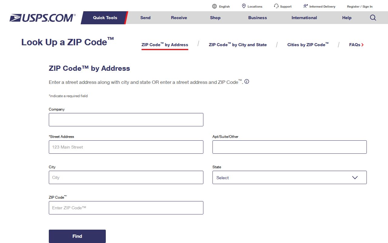
Use the displayed fields with a complete address, then compare the returned ZIP with the county's documented range and parcel record. The form does not replace a legal description, a County Mapper result, or a jurisdiction check.
Separate Buckhall ZIP and City
Buckhall is a Prince William County census-designated place, not an incorporated city. Many Buckhall addresses use Manassas as their mailing city. That familiar postal label should not be read as a City of Manassas jurisdiction decision. County parcel, court, tax, police, planning, election, and health routes serve Buckhall through Prince William County unless a record identifies a different custodian.
Keep three fields distinct: the postal city used for delivery, the place name used for Buckhall geography, and the county parcel or legal-description identity. A city or ZIP field can be useful when searching. It is not enough to decide a boundary question. County Mapper and a recorded plat can provide additional context, while the legal description controls the land record.
Postal labels are not jurisdiction labels. “Manassas” in a Buckhall mailing address is a delivery convention. Confirm the county parcel and civic geography before selecting an office or drawing a boundary conclusion.
Keep Buckhall ZIP Geography Distinct
A ZIP code, CDP, county line, city limit, precinct, and parcel are separate geographic systems. The official election material places the Buckhall precinct in Coles District. County Mapper can show a precinct or polling-place result through More Info, but that service layer is not a survey and does not define the full Buckhall CDP. The same caution applies to the county ZIP table.
Use a ZIP to narrow an address search. Use the parcel record for county property identity. Use the election map only for precinct context. The county research expressly warns against treating a service layer as proof of enrollment, residency, or a legal boundary. Recording the geography type next to each result prevents a postal result from being mistaken for a property conclusion.
Use Buckhall ZIPs With GPIN
Once an address has a delivery ZIP and county parcel result, record the GPIN. Prince William County uses this 10-digit proprietary grid identifier as the stable parcel key. It supports a reproducible cross-check between the property card, County Mapper, address research, and land-record history. The key is more durable than a changing street label or an old route name.
PublicAccessNow visibly offers Quick Search, Address Search, GPIN/Account Search, and Sales Search, although the captured official source did not expose every inner field or required flag. County Mapper accepts a full or partial GPIN and shows the format hint xxxx-xx-xxxx. Pair that value with the property address, legal description, source URL, and query date. Do not substitute the ZIP for the GPIN in a deed or parcel search.
Read Buckhall ZIP Assessment Labels
The county's 2022 “BUCKHALL” assessment summary is a county reporting label, not a Census geography or a complete ZIP code count. It lists 5,646 residential properties and an average improved residential assessed value of $443,299. Those assessment figures should stay attached to their 2022 county context. They should not be blended with a Census measure or used to define 20111.
This distinction matters because public data can use the same place word for different boundaries. The research separately identifies Buckhall CDP population figures and county assessment reporting. A ZIP-oriented search should label each number with its source geography and date before comparing it with a street range, mailing address, or parcel card.
Compare Buckhall Historic Addresses
Historic Buckhall research often starts before a modern ZIP or street number. RELIC's 1923 Rural Delivery Routes map can explain why a family appears under a route or post-office label instead of a present address. The 1933 highway map, 1962 county map, Street Directory, County Mapper, and legal description can be compared to track address drift without forcing an old record into a modern ZIP.
RELIC's regional directory and telephone holdings add time-specific address context, but the research did not find a complete Buckhall-only reverse directory or a verified individual entry. Preserve the volume, page, year, spelling, and address heading, then use a parcel, deed, map, or original record to test the match. Buckland is a different historic place near the Fauquier County line and should never be joined to Buckhall only because the names look alike.
Note: Preserve the historic route or postal label exactly as printed, then compare it with a map, parcel key, and legal description before assigning a modern ZIP.
Buckhall ZIP Code Terms and Limits
ZIP terms describe postal delivery tools. They do not create a land description or a complete roster of people connected to an area. Use the definitions below when reading an address result, and keep an official delivery result separate from county parcel and election research.
- ZIP and ZIP+4
- A ZIP identifies a postal delivery area. ZIP+4 adds a more specific delivery segment for an address or group of addresses.
- PO-box ZIP
- A postal ZIP used for post-office boxes. It does not by itself identify the location of a physical parcel.
- Unique ZIP
- A ZIP assigned to one organization or delivery point. It is not evidence of a neighborhood or county boundary.
- Carrier route
- A delivery sequence used by the postal service. It can aid mail organization but is not a legal parcel boundary.
Use official sources and a lawful personal purpose. Do not use address, parcel, ZIP, or directory details to stalk, harass, intimidate, or harm anyone. When a record appears incomplete, contact the custodian that holds it instead of trying to infer protected or missing information from postal data.